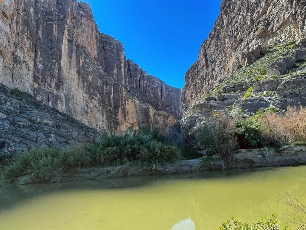
Located on the far end of Ross Maxwell Scenic Drive, the Santa Elena Canyon is one of the most imposing features in Big Bend National Park. The walls of the canyon rise steeply for over 1,500 feet on either side of the Rio Grande which makes up the border of the United States and Mexico.
The trail is short but one of the best in Big Bend National Park. Unpassable at times when the water level is high, the trail takes visitors along the steep canyons and waters of the Rio Grande and Terlingua Creek. We recommend the trail to everyone who can go, and we are here to help you. This guide will help you with how to hike the Santa Elena Canyon Trail.

About the Santa Elena Canyon Trail
Distance: 1.3 mile | Type: Out & Back| Avg. Time: 40 minutes | Difficulty: Moderate | Dog Friendly: No
Santa Elena Canyon is one of the main canyons within Big Bend National Park. The imposing walls feature dramatic 1,500 foot walls, rivers, boulders, and even a creek crossing. On one side of the river is Texas and the other side is Mexico and the sheer walls add to the impressive nature of the hike.
The hike takes you a bit over ½ mile along the Texas side of the canyon before turning around and returning to the trailhead. The Rio Grande makes up the boundary to one side of the hike and visitors will cross Terlingua Creek. This can sometimes be difficult depending on water levels and route.
There are areas where it looks like you could cross Rio Grande, but we recommend avoiding any action such as this or even the appearance. Entry to or from Mexico in this manner would be illegal.
Enjoy the hike, it is one of my favorite hikes within Big Bend National Park. It is certainly short but very sweet.

Santa Elena Canyon Trail Trailhead & Parking
The trailhead and parking for Santa Elena Canyon is located at the end of Santa Elena Canyon Road. The access to this area is via the long and scenic Ross Maxwell Scenic Drive.
The trailhead starts at the end of the parking lot. There are not a lot of parking spots available but they do tend to turn over pretty regularly. Most folks come here for either the trail or for usage of the beach where Terlingua Creek and the Rio Grande meet. It is also a popular launching point for river trips as well.
Santa Elena Canyon Trail is within the boundaries of Big Bend National Park, which is a national fee area. Be sure to have paid your entrance before hiking the trail.

Best Time to Do the Hike
The best and most popular times to hike Santa Elena Trail tend to be September – November and March – May. This is the time when the weather is generally the best in terms of heat for this part of the country.
Winters are also generally a reasonable time to visit Big Bend. December – February however the weather can be cold, especially at night. There is also a higher chance of precipitation during the winter months as well. Water temperatures can be cold in the winter too.
Summers at the park tend to be extremely hot. Expect high temperatures throughout the day. Be sure to pack extra water and be sensitive to heat exhaustion from exertion. The trail is quite exposed however the water in the creek is probably a nice respite from the heat.
The Santa Elena Canyon Trail Hike

The hike begins from the trailhead sign at one of the parking lot for the Santa Elena Canyon Trail. This area is pretty flat and calm with a boardwalk, and a mostly dirt trail. About 0.1 miles from the trailhead sign you’ll reach the bank of the Rio Grande where it meets Terlingua Creek.

Here you’ll see a small beach area and likely some kayaks along the water as well. This is a popular launching point for trips along the Rio Grande and through the canyons. Here the trail crosses Terlingua Creek. The proper trail route is through the creek.
Note: The creek can be quite deep at times. When we did it, it was up to my chest and I’m 5’11”, my shorter friend could not safely stand on the ground.

I ended up wading through the creek along with one of my friends. It was not exactly what I had expected, it was impossible to see where we were walking and the depth of the creek. For us It was also super muddy getting out of the creek, as the walls were terribly muddy. My friend had to boost me up so I could climb out and I needed to pull him up. We ended up caked in mud. If the water level is high or the walls super high you may have difficulty doing this part solo.

Alternative Route:
My friend’s sister was with us and she was not able or willing to cross the creek. We ran into other groups of folks who were traversing further down the trail and across. I went to check this out as well. About 0.1 miles down the creek from the beach was an area that was semi-dry in the creek bed. Here there was a steep cliff area that had a steep climb and descent section before connecting with a path to the main trail. This area is really tough with improper footwear and is generally tricky to navigate. The path is way steeper than it appears in the photo.
Note: I learned later that this is not recommended as it’s not a maintained trail. I don’t know if it is unallowed or just not recommended. Do so at your own risk.

From here the trail goes through a set of small switch backs. Don’t worry it’s steep at parts not not a huge ascent and it affords some of the best views over the Rio and Creek on the trail.
The trail here is pretty flat from here on out. It does descend a bit but generally is very easy and enjoyable.
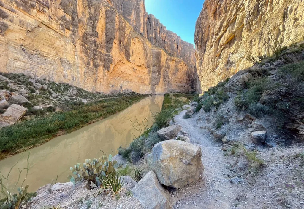
You’ll hike along the dirt trail here and with the river on the left of you. There’s a couple boulders and rocks that you can climb on to get some cool views as well as some cool photos of the area.
The trail has some cool plants and shrubs and rocks on the path. Just be sure to keep an eye out for snakes as they can hike in some of the rocks and brush in the area.
The trail does eventually end about .5 miles from the creek or about .65 miles in total from the start of the trail. It ends at a sheer rock face that blocks traveling any further unless you have a water vessel.
From here you head back on the trail in the same manner you came. You’ll need to cross the river again on your way back out. If the water is high be prepared to have folks on the beach gawk and possibly photograph you.
Tips & FAQs
- Bring Water. It is recommended at least 1 liter per person
- Bring Footwear you don’t mind getting muddy. But not flip-flops. If you wear sandals, wear ones you can strap securely to your feet.
- The Cliff Area is not part of the maintained trail. While many use it, it is not recommended.
- Wear a swimsuit and quick-drying clothes. It made the hike more enjoyable, drying fast.
Other Posts You May Like
- TEXAS: Best Things to Do in Bend Bend National Park
- TEXAS: Guide to the Congress Bridge Bats, Austin
- TEXAS: Best Day Trips from El Paso
- NEW MEXICO: Best Things to Do in Guadalupe Mountains NP
- NEW MEXICO: Guide to White Sands National Park
- MULTI: Epic Western US National Parks
Leave a Reply